Written by Damien Burrows
From being virtually unknown less than a year ago, Raspberry Falls has quickly become the must-see outdoor destination of the region. Its not hard to see why – a beautiful creek-line and amazing vistas, all within a relatively easy half-day walk. With a clearly cut track to the creek, this sublime sight is accessible for all. Last weekend, Townsville Hike and Explore undertook their first, of what surely will be many, trips to the falls.
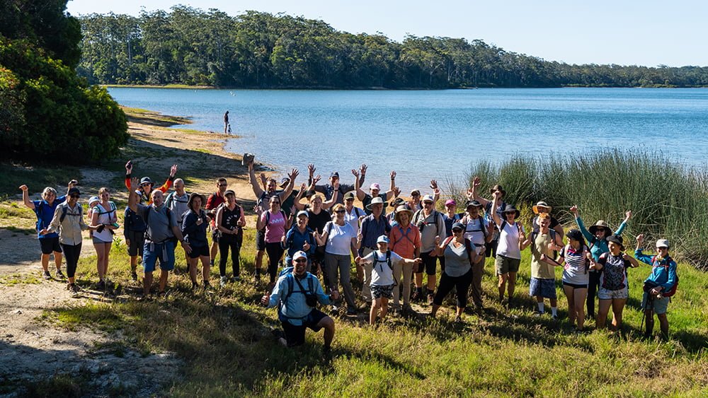
Excitement and demand for this trip has been building for some time and a good turnout of Townsville Hike and Explorers made the 2-hour journey from Townsville, also picking up 4 Ingham-based members along the way. A 1.5hr walk through rainforest and along the creek was met with collective gasps as the vista across the coastal plains from above the falls suddenly emerged. Everyone reached for their cameras. Most took the view in for a while before exploring the top tiers of the falls. For the second week in a row, we were blessed to watch the aerial dance of Ulysses blue butterflies against a magnificent vista whilst we ate lunch in warm winter sunshine.
The walk was relatively straight forward, though everybody arrived with wet and muddy feet/shoes and the more vertically-challenged, with wet pants – the various instream accoutrements of the creek providing an obstacle course of sorts to negotiate. Don’t be fooled by idyllic Instagram-style photos of the creek-line. Whilst beautiful, and some sections do have clear, shallow sandy beds, it is liberally infilled with boulders, Lomandra grasses, trees and fallen timber. It has some deep pools and muddy edges to negotiate, and wait-a-while patches along the banks. The walk along the creek takes <1hr and although its no simple unimpeded stroll along a sandy creek bed, it is quite doable for even moderately-fit, inexperienced walkers.
Overall, the 4.1km walk from Oak Hills Rd took us just over 1.5hrs but would be faster with a smaller group or by parking along the firebreak road, reducing the walk distance to 2.5km (see directions below). Wear shoes that can get wet and muddy but have good grip on slippery rocks. The Falls have many tiers. The upper two tiers are readily accessible but care should be taken – the downward sloping rock faces would be slippery when wet. Elevation at the car park was 690m and at the top of the falls 615m.
A scan of Google Earth indicates several other unheralded scenic creeklines in this area worthy of future exploration. Presently, a trip to Raspberry Falls could be combined with a 2km return walk up the dormant volcano of nearby (14km away) Mt Fox offering widespread 360 degree views, and completed with a drive home through Hidden Valley and Paluma, making a variety-filled day trip from Townsville. Even if not hiking up the Mt Fox volcano, when driving, don’t forget to look out for it on the western side of Oak Hills Rd. Its distinctive volcano shape is unmistakable.
Directions to Raspberry Falls
Raspberry Falls is in the Mt Fox district and the roads to the track are all signed and readily located on Google Maps. The trailhead is 61.8km from Ingham. From Ingham, head west toward Trebonne (8.7km) on the Abergowrie Rd. At Trebonne (last chance for coffee and toilet), turn left onto the Stone River/Mt Fox Rd and follow this for 41.3km (all bitumen) through cane fields, cattle paddocks and up the range to the junction with the Ewan/Furber Rd to Hidden Valley (the 38km dirt road to Hidden Valley, W of Paluma, is in great condition, suitable for 2WD, and a scenic alternative to the highway drive via Ingham). From this junction, keep straight ahead on Mt Fox Rd; after 6.4km, turn right onto Oak Hills Rd (dirt) and follow for a further 5.4km to the junction with the Western Raspberry Break road (not signed). You can park here and walk the 1.6km down the rainforest-lined dirt road to where the single track starts (1.6km on the left) or to shorten the walk, the firebreak road is generally suitable for 2WD vehicles except for one creek crossing ~690m along the road which is best suited for high clearance vehicles.
The walking track is not signed but is marked (1.6km on left down the dirt road @ -18.7866,145.8446) with a red tin can lid nailed to a tree. The 1.2km track through the rainforest to Raspberry Creek is clearly-defined and liberally marked with pink tape. Once at the creek, head downstream (left) for 1.3km. The first 250m along the creek are filled with instream boulders and Callistemon (bottlebrush) trees and it is easier to walk along the left bank for a while. After this, it is easier to walk in the creek channel, noting you will have to get your feet wet doing this and at some deeper pools, may have to access the left bank again (or swim through the pools). It would be very difficult to reach the falls without getting your feet (and for most, your waist area) wet, so dress for that. Submerged rocks in the creek near the falls are quite slippery too.