Location: Pinnacles Range
Article: Written by Damien Burrows; Imagery by Damien Burrows
Directions: Access is via private property
The Pinnacles Range stand as a sentinel forming a dramatic backdrop over western Townsville. Despite its proximity to town, the range has no roads or formal hiking tracks and is thus poorly explored. It is no wonder that it draws the more adventurous to unearth hidden delights.
Fulfilling the urge to explore our backyard, the annual Townsville Hike and Explore Pinnacles Traverse, though only now in its third year, has already become the stuff of legends. The inaugural traverse in 2019, a journey of discovery into the unknown, ended late into the night (and included an aerial medivac, though all ended well). The 2020 event was preceeded by a cracker of a thunderstorm the previous evening, resulting in draining, sultry conditions, hiking through dark, low hung clouds, discovery of a 8-10m high waterfall high in the range and upon dusk as we finished, a dramatic full arced rainbow marked our finish.
Expectations were thus high for the 2021 edition. Though it occurred in August, this story begins back in late April 2021 when Michael, Daniele and I flew over the Pinnacles with Townsville Helicopters. We were struck by the number of creeks emanating from the Pinnacles that still had flow/lots of water in them. Townsville’s late season rains working their magic no doubt, but we resolved to explore these creeklines, several of which were obscured under full canopy covers. One creekline in particular had us amazed – how was it that we had never seen nor heard of this creekline before? Its not far from town and when seen from the air, stands out like the proverbial. After the chopper ride, I thoroughly scanned options on QGlobe, confirming there was lots of wonders to be revealed under those canopies. But with busy schedules, it was to be 3 months before a group hike was organized. Would the water that so attracted us, still be present?
Like previous traverse’s this was planned as an up one side – across the top and down the other side – type of affair. From our parked cars, exchanging greetings in the dark, 10 of us set out in the pre-dawn, guided by our headlamps. We hit the sandy creekline just as the first flecks of sunlight filtered through the canopy. We needn’t have worried about water which was almost immediately evident. Before long, the delightfully shaded creek became rocky-lined and filled with small pools and gently flowing slides. We were repeatedly amazed by the sights unfolding before our eyes.
We stopped for a mid-morning swim at an azure-green waterhole (277m elevation) surrounded by dramatic rocky cliffs with a small waterfall at its head. The water was cold and delightful, the location so untouched and untrammeled. To progress further upstream, we had to exit the creekline and almost vertically ascend the hillside, attaining a commanding view of our swimming hole and the narrow rocky canyon above it. Returning to the heavily shaded creekline upstream of that obstacle, we bounded over rocks and boulders with renewed enthusiasm, energised by the sense of discovery and excitement. This is my favorite style of hiking, and despite the enjoyment, I was concerned that we were not gaining elevation fast enough. The uplands of the Pinnacles would be at least 500m high. If we were getting rapidly closer to the gorge’s terminus but not gaining enough elevation, that had to result in a significant vertical challenge at some point. And shortly thereafter, as the walls of the gorge became narrower and steeper, so it came to pass.


Just a few hours after our start, we had reached what would be the terminus of this route. A nice, rocky pool (at 406m elevation), dramatically surrounded on all sides by almost sheer cliffs, marked this spot. I struggled to ascend the trickling waterfall that filled this pool (and that would be a cracker in the wet season), and upon achieving that, found nothing but steep cliffs and ravines in front of me. We weren’t going any further up that way. Immediately before the pool, there were several steep erosions scars, littered with rocks, soil and woody debris. After some consideration, we determined to scramble up one of the erosion scars, hoping from there that we could attain the flatter grasslands above. The erosion scar was full of loose rocks and boulders, so much so, that we could only attempt the 50-60m climb one-by-one as dislodged rocks would cartwheel downwards. Unfortunately, our ascent, slow and cautious as it was, revealed that the head of the erosion scar emanated from a very narrow ravine, and it became obvious that the gorge could not be ascended from this location. We would have to return. Easier said than done though. The descent out of the erosion scar also had to be performed delicately, one-by-one. Overall, we spent a somewhat risky and certainly physically draining hour attempting and failing to ascend a 50-60m erosion scar. However we were not beaten and decided to recalibrate our plans and scout a smaller tributary creek we had noticed on the ascent, a short distance upstream of our green-tinged mid-morning swimming hole.
A quick descent had us back at the junction. We headed up this tributary, which also had a minor flow across some nice rockfaces that would be stunning sights in the wet season. Unlike the main creek, this creekline was gaining elevation consistently – a promising sign. After 30 minutes of fast ascent we had essentially run out of properly-formed creek but could navigate our way through shady dry rainforest which then gave way to steep rockfaces above which we could see the sun through the thinner vegetation that signified the sparser eucalypt woodlands we were seeking. Fortunately, we were able to pull ourselves up these rockfaces, aided by them being partly vegetated. Indicating that we were leaving the shady rainforest for drier habitats, we encountered thickets of lantana and had to cut our way through whilst at the same time scrambling up the steep slopes. The lantana represented a transition zone between the rainforest in the gorge and the woodlands above. This was hot and hard work but once we broke through the lantana zone, we almost immediately fell into a wonderland of eucalypts and native grasses. We had made it to the uplands.
I have walked over much of north Qld and the Pinnacles uplands are some of the finest country I have walked through. So much of our native grasslands and woodlands have been irrevocably altered by introduced invasive grasses and weeds. Apart from patches of lantana, the Pinnacles are largely weed-free and provide a glimpse into what the Australian bush once looked like.


As soon as we made it to the uplands, we stopped to catch our breath. We turned around and could see across to a section of Hervey’s Range, which for very obvious reasons is known as Tabletop. From this vantage point, it indeed looked as flat as a tabletop. That we were looking down on Hervey’s Range indicated the elevation we had gained. Fortunately now, we knew the hard work was behind us. No more ascending was required and we were in more familiar territory where we knew the going would be easier. However, given the delays in attaining the uplands we couldn’t linger long and Michael set a fast pace. We sequentially passed through a series of eucalypt, then melaleuca, then casuarina woodlands – all of them stunning. We also crossed some small drainage lines and inverted saucer-shaped landforms that would be swamp country in the wet season. There is quite the variety of vegetation and landforms to admire up there.
Before long, we had crossed the uplands and reached the front edge of the Pinnacles Range, about halfway between South Pinnacle (729m) and Frederick’s Peak (679m) where we could look down upon the Townsville plains below. Though we had initially hoped to do so, we didn’t have time to visit South Pinnacle (the highest peak in the range) so headed towards Fred’s. The walk along the cliff line here is a stunner – you are constantly partnered by almost unimpeded views over the Townsville plains but also of the rocky spires of Fred’s Peak from ever-changing angles. Those who just walk to the peak and back miss how interesting it is to see this rocky marvel from so many different angles and with so many different accompanying backdrops, ranging from Ross Dam to the northern beaches, Mt Margaret and the southern extent of the Paluma Range.
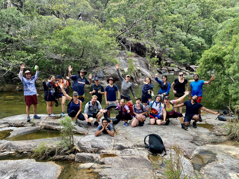
Upon reaching the backside of Fred’s Peak, we stopped for group photos with the descending sun, Fred’s Peak providing a stunning backdrop. Michael did a quick live post to the TH&E Facebook group and we began our descent. We made it to the bottom just before dark. But now lay a 90-minute walk to our cars across the flatlands. Here the condition of the dry woodlands, filled with introduced weeds, stands in stark contrast to the landscapes above. Despite this, with the setting sun, the walk around the base of the Pinnacles is also very interesting, providing bottom-up views of South Sentinel and also other potential gorges worthy of exploration that we had seen in our chopper flight months earlier. I resolved to ascend all of these in due course.


Despite being tired, sore and blistered, the pace was fast. Darkness enveloped us as we quickened the pace, following old vehicle tracks. The group clearly had their ‘lets get this done’ mojo set to maximum. I didn’t even stop to russle in my pack for my headlamp, not wanting to lose time. Plus I genuinely enjoy the experience of walking in the dark and the dirt tracks were safe underfoot.
Nearly 13 hours after we started, we arrived back at our cars. With barely a goodbye, we were off, drinks and pizza’s awaiting.
Another remarkable Pinnacles Traverse (or circuit in this case) completed. We fulfilled the promise we made that day staring down, wonderstruck, from the chopper, added to the growing legend of this event and further opened our eyes to the amazing landscapes in our backyard. Another amazing day of discovery thanks to Michael and Townsville Hike and Explore.

All of the lands we walked upon are crown land. Parts of the Pinnacles are already declared as National Park with the remainder likely to become so in the future. The landscapes protected therein are a tremendous asset to the region – lets hope they can be opened up for more to experience.
Total for the day – 27km hiked, ~900m total elevation gain, 12.5 hrs duration