Location: Mount Mackay National Park
Article: Written by Damien Burrows; Imagery by Damien Burrows
Directions: Access is via Silky Oak Tree Road (-17.965 145.970)
No doubt many of you have driven past an untracked, seemingly inaccessible mountain and wondered what the view is like from the top.
Last last year, driving back from a 4-day hiking adventure in the wet tropics with Michael Pugh, we drove through Tully. On the western (inland) side of Tully, stands 679m Mt Tyson. It has a rough but accessible track to the top. On the eastern (coastal) side of Tully, stands Mt Mackay. At 729m, slightly taller than its cross-town rival, but Mt Mackay stands out because it is an isolate. It is not a connected part of a mountain range – it stands alone and is surrounding on all sides by flat cane lands. This makes its triangular shape and distinct peak more prominent. When I tell people we hiked Mt Mackay – everyone says Mount What?? But when I say, y’know, that mountain at Tully that stands out beside the highway – everyone seems to recall having seen it.

So it was, with our spirits filled from 4 days of conquering peaks and waterfalls up north, we drove home past numerous untracked peaks, making plans to conquer them all. Among the many we added to our ‘to do’ list, Mt Mackay was at the top. We saw its irresistible shape and thought – without any other mountains getting in the way, the 360 degree view from up there must be awesome. You could surely see all of Mission Beach, across Dunk Island and south across the mouth of the Tully River amongst others. Though there are no tracks and we have never heard of anyone climbing it, we resolved to add Mt Mackay to our conquests and were back there within 2 weeks to do so.
There are no tracks up Mt Mackay and being in the path of recent cyclones, we figured, and could see on QGlobe, that there were many patches of tangled forest to be negotiated, especially nearer the summit. The summit itself should be clear and provide a 360 degree view as there is a communications tower and cleared surroundings up there, though with no path to get there (presumably accessed only by helicopter). On the plus side, Mt. Mackay is a National Park and there is a public road on its south side that runs parallel to the boundary, providing instant access to the mountain without crossing private property.
The four of us (myself, Michael, Rhett and Catherine) departed Townsville at 0300hrs and drove for 2.5hrs. Turning off the highway just south of Tully, Mt. Mackay looked graceful and peaceful – but we had no idea of the day ahead of us. The weather forecast was Ok, but being Tully in December, dark clouds were starting to gather in the distance.
We parked on the side of the road, beside a small creek that drains the mountain. This creek provided our access to the forest and although narrow and dry, it was almost vertical-sided, such that it was like walking in a narrow ravine. We had to scramble up one of the sides when we decided it was time to head through the forest itself. Though wait-a-whiles and various other thorny plants were plentiful, progress through the forest was reasonable. After about an hour, we began the more serious climb along the ridgeline that we hoped would take us to the summit. The ridgeline was narrow in many places, with steep slopes to either side. This narrowness made the ridgeline obvious, which simplified navigation, but also greatly limited options when we needed to avoid thick patches of tangled vegetation.
Although we tramped uphill along the ridgeline for several hours without relief, the gradient was at least consistently moderate rather than steep. However, the day was humid and there was not a puff of breeze in the forest. Though we had three secateurs working furiously to cut the thorny vines from our path, the scratches on our arms and legs began to accumulate. Progress was steady but slow (~1.5km/hr) with all the cutting.
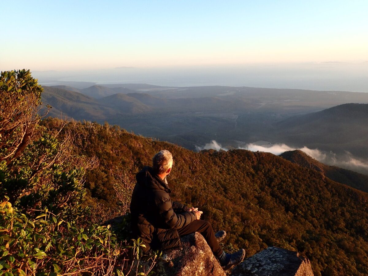
After several hours of consistent uphill, sweating and constant cutting, without having a break, we came upon our first views of the coast below, at around 400m elevation. We could see cane fields, Dunk Island and the mouth of the Tully River. We live-streamed a video to the TH&E Facebook page, all in high spirits – but that feeling wasn’t to last. The views were taunting us with the promises of what would come with greater elevation but the dark ceiling provided by a flat deck of gathering clouds above was getting much lower, enveloping the peak. Heavy rain was not far away.

At this elevation, on the ridgeline, we started to encounter many deforested patches that had been completely taken over by dense vegetation of one of two types. The first was dense monocultural swarths of coral fern, more than 2 metres high. Think of your garden ferns but 2m high and impossibly dense. They were so dense and entangled with each other, that it was impossible to work our way through them, even for short distances, or to cut through them, given their density. Our tactic for progressing through these fern swarths (remembering that we couldn’t go around them on the steep-sided ridgeline) was for the lead hiker to launch forward with their body onto the ferns and crush them with our bodyweight – each lunge turning a vertical fern swarth into a horizontal vegetative mat that, although it was still at least a foot thick off the ground level, could at least be (sort of) walked upon by those following the lunging leader. Each lunge and collapse netted about 5 feet of further progress, but was very physically taxing, not to mention the most unusual method of hiking that I have ever practiced. It was a huge relief to exit each fern patch and be back into forest, even with the thorny vines.
The second type of vegetation in cleared forest patches, fortunately less common than the ferns (that’s right, even worse than the fern patches) was a type of woody shrub to 3m high that also formed dense monocultural thickets. These could not be walked through, easily cut through or collapsed with bodyweight. As we neared to within a few hundred metres of the summit, we encountered one of these woody patches. At the same time, the dark clouds had completely closed in and it started to rain. After 5hrs of exhausting work ascending and cutting our way to this point, there we stood, within grasp of the summit, but facing a dense wall of woody thicket and realizing there would be no view from the summit to be attained today anyway, we reluctantly decided to call it a day.

Due to our early start, it was still not yet midday so we had time on our side. Knowing that the creek line we had started on and parked our car beside, also drained this section of the mountain, we thought we would see if we could follow that creek down. It would of course have been easier and safer to just follow the same path we had ascended, but this being an exploratory hike, we had to explore alternatives right! Those were famous last words and shortly thereafter, we were debating whose dumb idea it was to descend the creek line. First of all, as soon as we had left the ridgeline, we descended very steeply and sharply into the creek line. Within minutes, we were too deep in to consider scrambling (I mean scrambling by hands) back up to the ridgeline. The nascent creek was small but flowing nicely with the rain. Unfortunately, it was heavily criss-crossed, as creeklets in upland rainforest tend to be, by thorny vines. The creek was also very steep and the narrow rockfaces within were very slippery. Despite this being our supposed ‘rapid descent’, progress was both painful and painfully slow. We reasoned that as the creek descended and widened, the thorny vines and wait-a-whiles would get easier to avoid but after a while, we realized that further descent along the creek was not a viable option. Our GPS signaled that we were, in a straight line, just 600m from the ridgeline we had ascended earlier. However, the terrain was extremely steep, the vegetation thick, and cruelly, we discovered there was now another steep-sided ridgeline between us and our original ridgeline. Though it was only 600m away, we couldnt head laterally to our original ascending ridgeline – we would have to ascend all of our lost elevation to get back to near the point where we first left the original ridgeline, which by comparison, despite its tribulations, now seemed appreciably easier than our current situation. We were now a lot more tired than we had been when we began the descent, and the thought of the very steep ascent back to where we had first left the original ridgeline several hours earlier, truly sank our hearts. However, there was no other choice. We simply wouldn’t make it out at all by sticking to the current creek line. We had to regain our original path.
Despite our physical tribulations and the slight foolishness of our current situation down a steep, sometimes ravine-like creek line, the four of us retained high spirits and still managed many laughs. We are all experienced off-track explorers and this is part and parcel of that practice. It was now that I was appreciating the quality of our crew on this exploration. Eventually we scrambled our way back to the original ridgeline. We had endured considerable physical exertion and mental fatigue over the preceding 3hrs, just to end up near where we had originally left the ridgeline. When we first began our descent, we had plenty of time on our side and I had even entertained thoughts of knocking off another hike in the area that afternoon when we completed the descent. How foolish was that? After our side excursion ate up 3hrs without losing any elevation, we would now have to rush just to make it down before dark. We all had headlights, but with the rain and dense forest, still preferred to exit in daylight.

Now descending on our original ascent line, we could see where we had cut vines on our ascent, and more importantly, and gratefully, our paths of collapsed coral ferns were easily visible and could be traversed without the need for the body-lunging technique. We had three working secateurs on the ascent but such was the usage, two had broken, leaving just one to cut our way home. This was an essential task as, despite our cutting efforts on the ascent, there were still innumerable thorny vines, greatly slowing progress. If the final secateur had broken, it would have greatly slowed us down. The rain continued and we had now been saturated for hours and barely stopped for any breaks, but no one complained. The thorny vines and thought of exiting before dark kept us focused on the task at hand. Our spirits remained high and jovial. As we lost elevation and left the ridgeline for the last hour or so through the lowland forest, the pain of the thousands of cuts began to take its toll. I have mentioned the abundant and ever-present thorny vines and wait-a-while, but there were also, especially in the lower sections, many patches of shrub height pandanus with sharp but rigid metre-long leaf edges. We had no choice but to walk through these, each leaf edge providing the equivalent of a paper cut. On the ascent, I had laughed at these, joking about how many paper cuts I would have by days end. However, by days end, I was getting paper cuts on top of paper cuts on top of paper cuts, all of them infused with salty sweat. During the last hour of our descent, this was especially painful. Due to the humidity and no chance of sunburn, I had elected to wear shorts and a short-sleeved shirt, as is my usual garb. My arms and knees were slashed but my hands were worse. I could see hundreds of visible cuts and felt like I had many more. Blood from numerous tiger leech bites streamed down my arms and legs.
About half an hour before dark, we relocated the steep-sided creek that led us to our parked car. Back at the car, we devoured Catherine’s home-baked muffins, fruit and cold water. We threw our socks and boots into the back of the ute. Despite removing those highly offensive stink bombs, the olfactory evidence of an entire day of sweat, mud and soggy clothes was all too apparent. We were very keen to get home but also knew we needed a wash/swim. The location that involved the shortest detour off the highway was 5-Mile Creek, just south of Cardwell. We had to put up with the in-car stench for 40 minutes though. Upon arrival, we had stiffened up considerably and made the most inglorious swimming entrance you have ever seen. 5-Mile Creek has a sheer side that is accessed down a ladder into the water. The submersion into the water stung at our hundreds of ‘paper’ cuts. It was excruciating. Two nearby lady swimmers asked why we were squealing so much. Seriously – once in the water, I couldn’t swim. I could barely move and clung to the ladder like a lifeline. My knees were so badly slashed with cuts from the Pandanus shrubs that every single step was painful, as each involved a slight creasing of the cut and highly inflamed skin. My knee skin felt like scour pads. That night at home, I spent much time (after a long and painful shower) looking under a magnifier, extracting numerous thorns embedded in my skin. Those that I missed inflamed bright pink by the next day, which at least allowed me to identify them for extraction as well. Two months later, I still have some small scarring on my fingers and arms, and a small lump from a leech bite on my leg – reminders of Mt Mackay.
It might be strange, but by the time we had driven home that night, the car talk had already turned to a repeat visit to the mountain. Partly because of unfinished business – the mountain remains unconquered – but also that our tribulations for the day described above were due to the exploratory nature of our journey. With a cut path, the ridgeline we utilized would actually be a very suitable, only moderately-rated day hike and on a clear day, would provide a stunning panoramic view of an extensive length of coastline. Its always the first hike that is the hardest. Those following get to enjoy the benefits of the labours of the pioneers. Though we seriously entertained the notion of a repeat visit, our exploratory hike marked the beginning of the wet season which will surely erase all evidence of our visit. However, I am convinced this would be a worthwhile hike and that a track up Mt Mackay would make a great asset for the Tully region.