Location: Paluma Range National Park, North Queensland
Article: Written by Damien Burrows; Imagery by Michael Pugh
Most people know of various Paluma Range ascending-descending trails such as Bullocky Toms, Foxlee’s and Bambaroo Tracks, but now there is an additional option further south but its longer and harder than those tracks. Looking for a longer, harder, day hike pre-Xmas to round off a working year that hadn’t contained enough such adventures, Michael rang me with the idea of hiking a recently refined trail from Paluma down to the base of the range. I didnt need any more info than that – it sounded like just the tonic.
We parked a finisher car next to Ollera Creek at the base of the range off Caleo Rd. Local legend Nick Dametto MP gave up a 5am start to drop us off at Paluma, gratefully saving us an awful car shuffle at walks end.
Feeling fresh, the hike started in the morning mist at the Smiths Falls-PRB trailhead which is about 800m down road from the junction with McClellands Lookout at Paluma township. This is also the trailhead for the Paluma-Rollingstone-Bluewater (PRB) track which follows the same trail. There is room for a parked car on the side of the road and a series of steel post bollards prevent 4-wheel vehicle access down the trail.
The first 10km of the trail follows an old logging road through the rainforest and is thus an easy, shaded and well-defined stroll. The vertical sides of the old bulldozed road are evident in many places a metre or two to the side of the track. The track climbs gently from 860m to a maximum of 950m, then gently descends to 900m, skirting the escarpment headwaters of Little Crystal Creek (with partial glimpses of coastal views between the trees), to a small clearing suitable for a tent. With its width, gentle gradient and well-cleared trail, this first 10km would be very suitable for trail running.


After the small clearing at ~10km, the next section of the trail was not previously a logging road, and thus the nature of the trail changes dramatically, becoming narrow, more overgrown and with some short, steep descents along a rocky ridgeline. One such steep descent crosses Fruit Salad Creek (~13km from the start and more a narrow, moss-covered rocky chute than a creek, but flowing nicely). As the trail ascends out of the creek, the vegetation is drier and the trail follows the side contour of a slope for about 600m (not good for those whose ankles dont appreciate sloping surfaces). Thereafter follows a descent to Smith Creek Falls at 14km from the start and now down at 610m elevation. Both Fruit Salad Creek (not an official name) and Smith Creek Falls (~3-4m high) are marked with small red signs nailed to trees.


3.5hrs since we started that morning, we stopped for a brief, chilling swim at Smith Creek Falls, where it is also worth an easy 5min explore above the falls to a smaller waterfall and pleasant waterhole. Interestingly, rather than draining to the coast, as close as 13km away in a straight line, Smith Creek actually drains down to the Star River and thence into the Burdekin River, debauching to the coast downstream of Ayr, nearly 300km away.
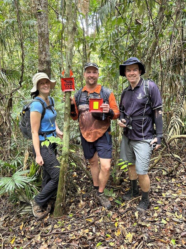


After a 20 min rest and explore, we departed Smith Creek, climbing steeply through a drier forest with a grass and grasstree understory. The trail now followed the opposite hill side contour to before (evening out the ankle tension!!). 20 minutes after leaving Smith Creek Falls, we arrived at the gently flowing and imaginatively named Pancake Creek (15.2km, 571m elevation). We didn’t have time to stop and rest but at least we were back in shady rainforest for a long steep climb, arriving 20 minutes later at the turnoff (the trail ahead continues the PRB track) to Ollera Valley lookout (15.9km 630m elevation).


The trail to the lookout descended very steeply down to a dry rocky creek, then ascended again to the lookout which is not one specific location but a sheer-sided escarpment that overlooks the entire Ollera Creek Valley. Views can be obtained at various points along this escarpment edge (at 600m elevation and 5hrs since we started). The drier vegetation and clearer understorey here enables easy traversement of the escarpment and views. As we enjoyed cooling valley breezes with our lunch, we could see the entire Ollera Creek Valley down to the coast (where our afternoon walking would take us), as well as surrounding landmarks such as Big Rock and Circle View Mountain.


After a short lunch break, and the obligatory group photos, at midday, we began the descent down to the valley. We had joked that the fastest way down to the shady cool waters of Ollera Creek was straight down the escarpment. Well the path wasnt much different. The first 10 minutes were super steep, of the slide-on-your-backside variety, and the ridgeline was very narrow at times. After 10 minutes, the ridgeline become slightly wider and the super steep trail ‘shallowed out’ to being just ‘very steep’. The gradient never let up either – not even briefly. After 1hr10mins of knee-locking, toe-jarring descent, we arrived at a dry rocky creek, turned left and followed it for 100m to its junction with the shady and sweetly flowing Ollera Creek, just downstream of Mickle’s Entry (a trail junction with Ollera Creek). We washed our faces and refilled our water bottles here.
It was now 6.5hrs since our start. We had covered 17.5km and were now down to 280m elevation, but the hardest part of the day was still to come. Following Ollera Creek itself would lead to our car but there is also a well-marked trail that parallels Ollera Creek. As the rocks were dry, we rock-hopped downstream for 40 minutes but then rationalised that the trail might be quicker. And so it was for a little while but then began yet another very steep, rope-assisted climb and descent, arriving at Lizard Gorge one hour later (20.3km). Although the whole morning had been pleasantly cool and the valley lookout provided cooling breezes, the afternoon in the forest was now a still, stinker. Saturated in sweat, and fighting off foot cramps in my case, we threw ourselves into Lizard Gorge pool (this is why its a Townsville Hike and Explore favourite).
After we left Lizard Gorge, we eschewed the creekline and again followed the trail. Yet again, more seriously steep (though gratefully shortish) ascents (some also rope-assisted) and descents further tested our energy levels in the afternoon heat. Finally, at 1730hrs, after nearly 11hrs in total, and 4hrs since we first reached Ollera Creek, we arrived at our car and dived for the drinks esky.


For what appears on paper to be a predominantly descending trail, our stats totalled 25km, 11hrs duration (9hrs moving time), 1025m total elevation gain and 1691m total descent. Most of these numbers were achieved in ‘steep’ mode. This is a serious day out. No wonder my quads and feet were still complaining days later.
The trail is mostly rainforest and liberally marked with pink tape, and markers nailed to trees. It is also quite clear at the moment. We were able to follow the trail at all times, referring to our GPS more for reassurance than necessity. However, the trail condition can change quickly and, Smith Creek excepted, we wouldn’t attempt this trail without a GPS and off-trail navigation skills.
There are a number of other options for this hike. A return hike to Smith Creek Falls would be ~4hrs (14km) each way but the going is easy and relaxed. Ollera Valley lookout is only another 1hr further. That’s still a full day return and also well over 1000m elevation gain and descent (mostly after Smith Creek Falls). The descent and ascent between Pancake Creek and Ollera Valley lookout is particularly steep and although presently clear, the narrow trail could be rapidly overgrown. Ollera Valley lookout could also be accessed from the bottom of the range, but it’s a 4hr hike each way along the valley (either rock-hopping the creek or following the up and down paralleling trail) then a long, extremely steep and unrelenting ascent to the lookout – one I wouldn’t relish.
Paluma to Ollera Creek Traverse – Walk Chronology
0.0 start at steel post bollards at -19.0108 146.2181
1:00 5.0km* Taffie’s Rest (signed – continue ahead)
1:40 8.6km* very small waterhole on side of path (continue ahead)
1:50 Track junction sign (ignore) and Ollera Way sign (continue ahead)
2:00 9.8km* small campsite clearing (not signed – continue ahead)
3:15 13.0km* Fruit Salad Creek (signed)
3:35 14.0km Smith Falls -19.048 146.267 (signed), 610m elevation
4:20 15.2km Pancake Creek (signed – continue ahead), 571m elevation
4:45 15.9km 630m elevation, turn left off PRB track to Ollera Valley Lookout (signed)
5:00 16.5km arrive at Ollera Valley lookout (-19.056 146.281) (signed), 600m elevation
5:30 depart lookout, begin very steep, unrelenting descent
6:40 17.5km arrive at Ollera Creek (-19.05534 146.28637), 280m elevation
8:30 20.3km arrive Lizard Gorge (-19.0429 146.2878) (not signed)
8:50 depart Lizard Gorge
10:50 24.9km finish at private property off Caleo Rd. (distance to car will be ~700m longer if not accessed via private property).
* Estimated distances from GPS watch. All other distances taken from handheld GPS.
How to get there
Access information – info@townsvillehikeandecplore.com


